Dust off the backpack, get new laces for those hiking boots. This is the place. California’s isolated “Lost Coast”—virtually uninhabited and more remote than any other stretch of coastline in the Lower 48—has been found. Here steep mountains soar like bald eagles, their domes tufted with chaparral, a few redwoods tucked behind the ears, and sink their rock-knuckled, grassy talons into surf that surges onto black-sand beaches. Local people, of course, snort over the very idea that this splendid stretch of unfriendly coast was ever lost in the first place, even if area highways were intentionally routed away from it. They knew it was here. And others have known, too, for at least 3,000 years.
Much of the Lost Coast is included in two major public preserves. Some 35 miles of coastline connect Sinkyone Wilderness State Park in Mendocino County with 65,000-acre King Range National Conservation Area in Humboldt County. Central to the long battle over expanding the Sinkyone Wilderness was the fate of 75-acre Sally Bell Grove along Little Jackass Creek. The prolonged political skirmish between former property owner Georgia-Pacific (which planned to clearcut the area) and various private and public agencies focused first on the value of these thousand-year-old trees to posterity. But the war was also over preserving reminders of a lost culture.
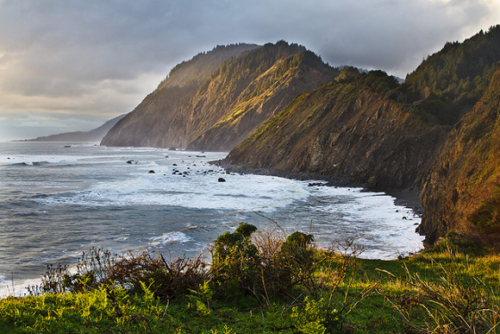
Whale Gulch (photo by Michael Mees)
Archaeologists believe proto-Yukian people occupied a site in the middle of Sally Bell 3,000 to 8,000 years ago. Chipped-stone tools, stonecutting implements, milling tools, the remains of two houses, and charcoal from long-ago campfires have been discovered. Since at least 2,500 years up until a century ago, the Sinkyone and Mattole peoples lived permanently along this vast seaside stretch, though other groups came here seasonally when the valleys inland roasted in 100-degree heat. The living was easy, with abundant seafood a dietary staple.
The beaches fringing the King Range were sacred to the Mattole. Descendants talk about the legendary wreck of a Spanish ship along the coast from which the locals retrieved triangular gold coins for their children to play with. The coins were lost, however, when their caves along the coast collapsed after the 1906 earthquake.
Getting Here (and Not Getting Lost)
Visiting the Lost Coast requires first getting there, something of a challenge. Roads here are not for the faint of heart nor anyone with an unreliable vehicle. Unpaved roads are rough and rugged even under the best weather conditions; some wags refer to driving the area as “car hiking.” Though Lost Coast road signs usually disappear as fast as they go up (the locals’ way of sending a message), existing signs that state Steep Grade—Narrow Road: Campers and Trailers Not Advised roughly translate as “Prepare to drive off the end of the earth, then dive blindly into a fogbank.”
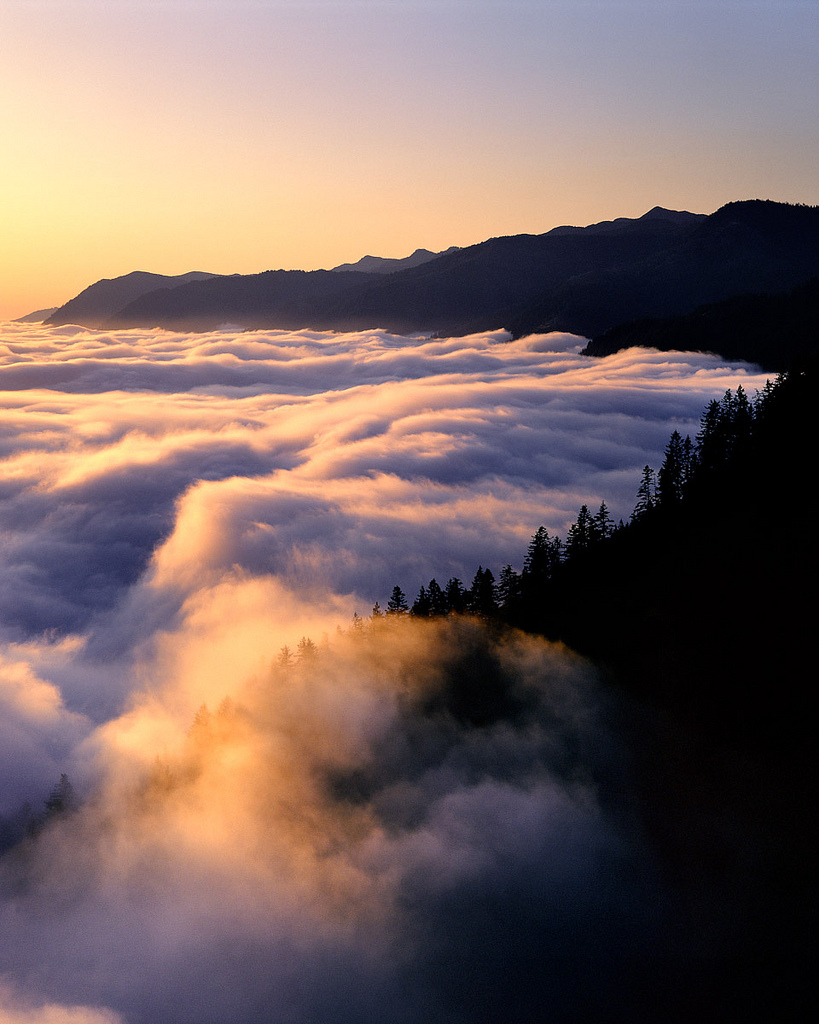
King Range (photo by Bob Wick)
From Humboldt Redwoods State Park, take Bull Creek Rd. west through the park and over the rugged mountains down to Honeydew. There turn north on Mattole Rd. and continue north to Petrolia, near the north end of the King Range National Conservation Area. Lost Coast hikers “going the distance” south along the King Range beaches to Shelter Cove often start outside Petrolia, near the squat old lighthouse (reached via Lighthouse Road). Arrange a shuttle system, with pickup at Shelter Cove, to keep it a one-way trip (paid shuttle services are available).
The easiest path to the sea is steep, narrow, and serpentine Shelter Cove Rd., which ends up at the hamlet of Shelter Cove, roughly midway down the Lost Coast; from Garberville, take Frontage Rd. one mile to Redway, and go west 26 miles on Briceland/Shelter Cove Road. Off of this road, you can turn north on wild Wilder Ridge Rd., which connects with Mattole Rd. near Honeydew, or turn south on either Briceland Rd. or Chemise Mountain Rd. to reach Sinkyone Wilderness (the last nine miles are unpaved, 4WD-only in winter and never suitable for RVs or trailers). At Four Corners junction, you can take Bear Harbor Rd. down to the ocean at Needle Rock and Bear Harbor, or head south on Usal Rd., which eventually joins Hwy. 1.
If you’re coming north from the Mendocino area via Hwy. 1, get to Sinkyone Wilderness from Usal Rd., which turns north off Hwy. 1 a few miles north of Rockport (watch carefully—it’s easy to miss).
The King Range
The northern reaches of the Lost Coast take in the King Range Conservation Area, and stretch 35 miles from south of the Mattole River to Whale Gulch. Most people come here to “beach backpack,” hiking north to south in deference to prevailing winds. The trailhead begins near the mouth of the Mattole River. Get there from Mattole Rd. near Petrolia via Lighthouse Rd., then head south on foot. After about three miles, you’ll come to the relict Punta Gorda light station; the rocks nearby harbor a seabird colony and a rookery for Steller’s sea lions. You can hike all the way south to Shelter Cove, a two- or three-day trip one-way (five days roundtrip), but a longer trek if you head on to Sinkyone.
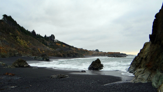
Shelter Cove (photo by Rene Rivers)
The trail saunters along miles of sandy beaches, around some tremendous tidepools, and up onto headlands to bypass craggy coves. In wintry weather it’s quite the wild walk (check conditions before setting out); in any season, watch for rattlesnakes on rocks or draped over driftwood. Between self-protective downward glances, look around to appreciate some of the impressive shipwrecks scattered along the way. Also just offshore in proper season are gray whales, killer whales, porpoises, and harbor seals. Inland, forming an almost animate wall of resistance, are the mountains, their severity thinly disguised by redwoods and Douglas fir, forest meadows, chaparral scrub, and spring wildflowers. Make camp on high ground well back from the restless ocean, and always adhere to the backpacker’s credo: if you pack it in, pack it out.
Sinkyone Wilderness
Sinking into Sinkyone is like blinking away all known life in order to finally see. Named for the Sinkyone people, who refused to abandon their traditional culture and hire on elsewhere as day laborers, this place somehow still honors that indomitable spirit.
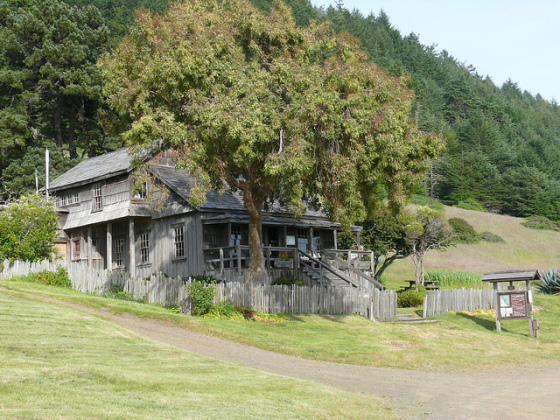
Visitor Center, Sinkyone Wilderness (photo by Rene Rivers)
At Sinkyone Wilderness State Park jagged peaks plunge into untouched tidepools where sea lions and seals play. Unafraid here, wildlife sputters, flutters, or leaps forth at every opportunity. The land seems lusher, greener, with dark virgin forests of redwoods and mixed conifers, rich grassland meadows, waterfalls, fern grottos. The one thing trekkers won’t find (yet) among these 7,367 wild acres is a vast trail system. Many miles of the coast are accessible to hikers, though, and the trail system includes a north/south trail and some logging roads. Sinkyone Wilderness State Park is always open for day use, and also offers scattered primitive campsites.


The Lost (and Found) Coast
Dust off the backpack, get new laces for those hiking boots. This is the place. California’s isolated “Lost Coast”—virtually uninhabited and more remote than any other stretch of coastline in the Lower 48—has been found. Here steep mountains soar like bald eagles, their domes tufted with chaparral, a few redwoods tucked behind the ears, and sink their rock-knuckled, grassy talons into surf that surges onto black-sand beaches. Local people, of course, snort over the very idea that this splendid stretch of unfriendly coast was ever lost in the first place, even if area highways were intentionally routed away from it. They knew it was here. And others have known, too, for at least 3,000 years.
Much of the Lost Coast is included in two major public preserves. Some 35 miles of coastline connect Sinkyone Wilderness State Park in Mendocino County with 65,000-acre King Range National Conservation Area in Humboldt County. Central to the long battle over expanding the Sinkyone Wilderness was the fate of 75-acre Sally Bell Grove along Little Jackass Creek. The prolonged political skirmish between former property owner Georgia-Pacific (which planned to clearcut the area) and various private and public agencies focused first on the value of these thousand-year-old trees to posterity. But the war was also over preserving reminders of a lost culture.
Whale Gulch (photo by Michael Mees)
Archaeologists believe proto-Yukian people occupied a site in the middle of Sally Bell 3,000 to 8,000 years ago. Chipped-stone tools, stonecutting implements, milling tools, the remains of two houses, and charcoal from long-ago campfires have been discovered. Since at least 2,500 years up until a century ago, the Sinkyone and Mattole peoples lived permanently along this vast seaside stretch, though other groups came here seasonally when the valleys inland roasted in 100-degree heat. The living was easy, with abundant seafood a dietary staple.
The beaches fringing the King Range were sacred to the Mattole. Descendants talk about the legendary wreck of a Spanish ship along the coast from which the locals retrieved triangular gold coins for their children to play with. The coins were lost, however, when their caves along the coast collapsed after the 1906 earthquake.
Getting Here (and Not Getting Lost)
Visiting the Lost Coast requires first getting there, something of a challenge. Roads here are not for the faint of heart nor anyone with an unreliable vehicle. Unpaved roads are rough and rugged even under the best weather conditions; some wags refer to driving the area as “car hiking.” Though Lost Coast road signs usually disappear as fast as they go up (the locals’ way of sending a message), existing signs that state Steep Grade—Narrow Road: Campers and Trailers Not Advised roughly translate as “Prepare to drive off the end of the earth, then dive blindly into a fogbank.”
King Range (photo by Bob Wick)
From Humboldt Redwoods State Park, take Bull Creek Rd. west through the park and over the rugged mountains down to Honeydew. There turn north on Mattole Rd. and continue north to Petrolia, near the north end of the King Range National Conservation Area. Lost Coast hikers “going the distance” south along the King Range beaches to Shelter Cove often start outside Petrolia, near the squat old lighthouse (reached via Lighthouse Road). Arrange a shuttle system, with pickup at Shelter Cove, to keep it a one-way trip (paid shuttle services are available).
The easiest path to the sea is steep, narrow, and serpentine Shelter Cove Rd., which ends up at the hamlet of Shelter Cove, roughly midway down the Lost Coast; from Garberville, take Frontage Rd. one mile to Redway, and go west 26 miles on Briceland/Shelter Cove Road. Off of this road, you can turn north on wild Wilder Ridge Rd., which connects with Mattole Rd. near Honeydew, or turn south on either Briceland Rd. or Chemise Mountain Rd. to reach Sinkyone Wilderness (the last nine miles are unpaved, 4WD-only in winter and never suitable for RVs or trailers). At Four Corners junction, you can take Bear Harbor Rd. down to the ocean at Needle Rock and Bear Harbor, or head south on Usal Rd., which eventually joins Hwy. 1.
If you’re coming north from the Mendocino area via Hwy. 1, get to Sinkyone Wilderness from Usal Rd., which turns north off Hwy. 1 a few miles north of Rockport (watch carefully—it’s easy to miss).
The King Range
The northern reaches of the Lost Coast take in the King Range Conservation Area, and stretch 35 miles from south of the Mattole River to Whale Gulch. Most people come here to “beach backpack,” hiking north to south in deference to prevailing winds. The trailhead begins near the mouth of the Mattole River. Get there from Mattole Rd. near Petrolia via Lighthouse Rd., then head south on foot. After about three miles, you’ll come to the relict Punta Gorda light station; the rocks nearby harbor a seabird colony and a rookery for Steller’s sea lions. You can hike all the way south to Shelter Cove, a two- or three-day trip one-way (five days roundtrip), but a longer trek if you head on to Sinkyone.
Shelter Cove (photo by Rene Rivers)
The trail saunters along miles of sandy beaches, around some tremendous tidepools, and up onto headlands to bypass craggy coves. In wintry weather it’s quite the wild walk (check conditions before setting out); in any season, watch for rattlesnakes on rocks or draped over driftwood. Between self-protective downward glances, look around to appreciate some of the impressive shipwrecks scattered along the way. Also just offshore in proper season are gray whales, killer whales, porpoises, and harbor seals. Inland, forming an almost animate wall of resistance, are the mountains, their severity thinly disguised by redwoods and Douglas fir, forest meadows, chaparral scrub, and spring wildflowers. Make camp on high ground well back from the restless ocean, and always adhere to the backpacker’s credo: if you pack it in, pack it out.
Sinkyone Wilderness
Sinking into Sinkyone is like blinking away all known life in order to finally see. Named for the Sinkyone people, who refused to abandon their traditional culture and hire on elsewhere as day laborers, this place somehow still honors that indomitable spirit.
Visitor Center, Sinkyone Wilderness (photo by Rene Rivers)
At Sinkyone Wilderness State Park jagged peaks plunge into untouched tidepools where sea lions and seals play. Unafraid here, wildlife sputters, flutters, or leaps forth at every opportunity. The land seems lusher, greener, with dark virgin forests of redwoods and mixed conifers, rich grassland meadows, waterfalls, fern grottos. The one thing trekkers won’t find (yet) among these 7,367 wild acres is a vast trail system. Many miles of the coast are accessible to hikers, though, and the trail system includes a north/south trail and some logging roads. Sinkyone Wilderness State Park is always open for day use, and also offers scattered primitive campsites.